Denver
 |
 |
Denver is located in the Southwestern United States, in the South Platte River Valley on the western edge of the High Plains just east of the Front Range of the Rocky Mountains. Its downtown district is immediately east of the confluence of Cherry Creek and the South Platte River, approximately 12 mi east of the foothills of the Rocky Mountains. It is named after James W. Denver, a governor of the Kansas Territory. It is nicknamed the Mile High City because its official elevation is exactly one mile (5280 ft) above sea level. The 105th meridian west of Greenwich, the longitudinal reference for the Mountain Time Zone, passes directly through Denver Union Station.
Denver is ranked as a Beta world city by the Globalization and World Cities Research Network. The 10-county Denver-Aurora-Lakewood, CO Metropolitan Statistical Area had a population of 2,963,821 at the 2020 United States census, making it the 19th most populous U.S. metropolitan statistical area. The 12-county Denver-Aurora, CO Combined Statistical Area had a population of 3,623,560 at the 2020 United States census, making it the 17th most populous U.S. primary statistical area. Denver is the most populous city of the 18-county Front Range Urban Corridor, an oblong urban region stretching across two states with a population of 5,055,344 at the 2020 United States Census. Its metropolitan area is the most populous metropolitan area within a 900 km radius and the second most populous city in the Mountain West after Phoenix, Arizona. In 2016, it was named the best place to live in the United States by U.S. News & World Report.
The greater Denver area was inhabited by several Indigenous peoples such as Apaches, Utes, Cheyennes, Comanches, and Arapahoes. Native American names for Denver include Niineniiniicie, Kʼįįshzhíníńlį́, and Tüapü (Ute). By the terms of the 1851 Treaty of Fort Laramie between the United States and various tribes including the Cheyenne and Arapaho, the United States unilaterally defined and recognized Cheyenne and Arapaho territory as ranging from the North Platte River in present-day Wyoming and Nebraska southward to the Arkansas River in present-day Colorado and Kansas. This definition specifically encompasses the land of modern Metropolitan Denver. However, the discovery in November 1858 of gold in the Rocky Mountains in Colorado (then part of the western Kansas Territory) brought on a gold rush and a consequent flood of white emigration across Cheyenne and Arapaho lands. Colorado territorial officials pressured federal authorities to redefine and reduce the extent of Indian treaty lands.
In the summer of 1858, during the Pike's Peak Gold Rush, a group of gold prospectors from Lawrence, Kansas, established Montana City as a mining town on the banks of the South Platte River in what was then western Kansas Territory, on traditional lands of Cheyenne and Arapaho. This was the first historical settlement in what was later to become the city of Denver. The site faded quickly, however, and by the summer of 1859 it was abandoned in favor of Auraria (named after the gold-mining town of Auraria, Georgia) and St. Charles City.
On November 22, 1858, General William Larimer and Captain Jonathan Cox, Esquire, both land speculators from eastern Kansas Territory, placed cottonwood logs to stake a claim on the bluff overlooking the confluence of the South Platte River and Cherry Creek, across the creek from the existing mining settlement of Auraria, and on the site of the existing townsite of St. Charles. Larimer named the townsite Denver City to curry favor with Kansas Territorial Governor James W. Denver. Larimer hoped the town's name would help it be selected as the county seat of Arapahoe County, but unbeknownst to him, Governor Denver had already resigned from office. The location was accessible to existing trails and was across the South Platte River from the site of seasonal encampments of the Cheyenne and Arapaho. The site of these first towns is now occupied by Confluence Park near downtown Denver. Edward W. Wynkoop came to Colorado in 1859 and became one of the founders of the city. Wynkoop Street in Denver is named after him.
Larimer, along with associates in the St. Charles City Land Company, sold parcels in the town to merchants and miners, with the intention of creating a major city that would cater to new immigrants. Denver City was a frontier town, with an economy based on servicing local miners with gambling, saloons, livestock and goods trading. In the early years, land parcels were often traded for grubstakes or gambled away by miners in Auraria. In May 1859, Denver City residents donated 53 lots to the Leavenworth & Pike's Peak Express in order to secure the region's first overland wagon route. Offering daily service for "passengers, mail, freight, and gold", the Express reached Denver on a trail that trimmed westward travel time from twelve days to six. In 1863, Western Union furthered Denver's dominance of the region by choosing the city for its regional terminus.
On February 18, 1861, six chiefs of the Southern Cheyenne and four of the Arapaho signed the Treaty of Fort Wise with the United States at Bent's New Fort at Big Timbers near what is now Lamar, Colorado. They ceded more than 90 percent of the lands designated for them by the Fort Laramie Treaty, including the area of modern Denver. Some Cheyennes opposed to the treaty, saying that it had been signed by a small minority of the chiefs without the consent or approval of the rest of the tribe, that the signatories had not understood what they signed, and that they had been bribed to sign by a large distribution of gifts. The White-settler territorial government of Colorado, however, claimed the treaty was a "solemn obligation" and considered that those Indians who refused to abide by it were hostile and planning a war.
Ten days later, on February 28, 1861, the Colorado Territory was created, Arapahoe County was formed on November 1, 1861, and Denver City was incorporated on November 7, 1861. Denver City served as the Arapahoe County Seat from 1861 until consolidation in 1902. In 1867, Denver City became the acting territorial capital, and in 1881 was chosen as the permanent state capital in a statewide ballot. With its newfound importance, Denver City shortened its name to Denver. On August 1, 1876, Colorado was admitted to the Union.
This disagreement on the validity of Treaty of Fort Wise escalated to bring about the Colorado War of 1864 and 1865, during which the brutal Sand Creek massacre against Cheyenne and Arapaho peoples occurred. The aftermath of the war was the dissolution of the reservation in Eastern Colorado, the signing of Medicine Lodge Treaty which stipulated that the Cheyenne and Arapaho peoples would be relocated outside of their traditional territory. This treaty term was achieved, even though the treaty was not legally ratified by the tribal members, as per the treaty's own terms. Thus, by the end of 1860s, this effectively and completely cleared the Denver area of its indigenous inhabitants.
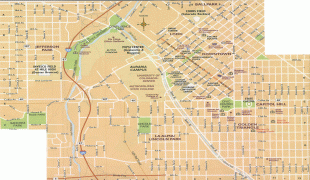
Map - Denver
Map


Country - United_States
 |
 |
| Flag of the United States | |
Indigenous peoples have inhabited the Americas for thousands of years. Beginning in 1607, British colonization led to the establishment of the Thirteen Colonies in what is now the Eastern United States. They quarreled with the British Crown over taxation and political representation, leading to the American Revolution and proceeding Revolutionary War. The United States declared independence on July 4, 1776, becoming the first nation-state founded on Enlightenment principles of unalienable natural rights, consent of the governed, and liberal democracy. The country began expanding across North America, spanning the continent by 1848. Sectional division surrounding slavery in the Southern United States led to the secession of the Confederate States of America, which fought the remaining states of the Union during the American Civil War (1861–1865). With the Union's victory and preservation, slavery was abolished nationally by the Thirteenth Amendment.
Currency / Language
| ISO | Currency | Symbol | Significant figures |
|---|---|---|---|
| USD | United States dollar | $ | 2 |
| ISO | Language |
|---|---|
| EN | English language |
| FR | French language |
| ES | Spanish language |